The Battle of Murten, 1476
Depictions of the Battle
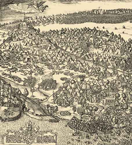
Fribourg had commissioned a painting of the battle from the artist Heinrich Bichler of Berne as early as 1480. Until the early 19th century it was stored in the town hall in Fribourg, but it was lost shortly afterwards. Martin Martini reproduced the depiction in a large copperplate engraving in 1606. It remains the most important picture source for the course of the battle.
19th century historians took
a keen interest in retracing the course of the battle based
on the written documents that had survived. The first such
attempts were made by Emanuel von Rodt (1843/44), Gottlieb
Friedrich Ochsenbein (1876) and Ulrich Meister (1877).
In 1894 Hans Wattelet, a legal expert and amateur historian
from Murten, published an analysis which is still considered
valid to this day. Braun and Wattelet were in close contact.
Louis Braun based his panorama on Wattelet’s findings, and in 1974
Georges Grosjean expanded on them in his study of Martini’s engraving.
Von Rodt placed the main Burgundian encampment and the
Grünhag to the west of Cressier, far from the besieged town of Murten;
he sited the camps of the Count of Romont and the Lombards
down by the lake, at Muntelier and Merlach.
Meister situated Charles’s tent on the vine-covered hill near Courgevaux;
he put the troops’ camps around Murten and the Grünhag to the
west of Cressier.
Wattelet, for his part, relocated Charles’s Ducal command tent on
top of Bois Domingue, a hill overlooking the besieged town
and the army camp, as Martini’s engraving and early chronicle pictures
show. He located the Grünhag on the steep slope facing Salvenach.